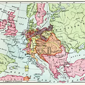
Home > Fine Art Finder > Maps (celestial & Terrestrial)
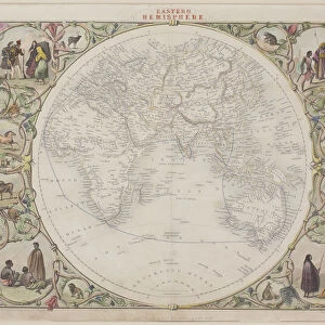
A general map of the world or terraqueous globe by Samuel Dunn, 1787 (engraving)
")
![]()
Wall Art and Photo Gifts from Fine Art Finder
A general map of the world or terraqueous globe by Samuel Dunn, 1787 (engraving)
XOS1765709 A general map of the world or terraqueous globe by Samuel Dunn, 1787 (engraving) by English School, (18th century); 106x128 cm; New York Public Library, USA; (add.info.: A general map of the world, or terraqueous globe with all the new discoveries and marginal delineations, containing the most interesting particulars in the solar, starry and mundane system); English, out of copyright
Media ID 12742545
© www.bridgemanimages.com
Atlas Celestial Globe Hemispheres Hydrography Latitude Longitude Navigation Planets Sea Chart Shipping Terrestrial Voyages World Map
FEATURES IN THESE COLLECTIONS
> Fine Art Finder
> Maps (celestial & Terrestrial)
> Fine Art Finder
> Schools
> English School
EDITORS COMMENTS
This engraving, titled "A general map of the world or terraqueous globe" is a remarkable piece of cartography created by Samuel Dunn in 1787. With its intricate details and meticulous craftsmanship, this print offers a glimpse into the knowledge and understanding of the world during the 18th century. Measuring an impressive 106x128 cm, this map showcases all the new discoveries and marginal delineations known at that time. It encompasses not only terrestrial features such as continents, countries, coastlines, and oceans but also delves into celestial elements like stars and planets. The inclusion of both solar and starry systems adds depth to our understanding of the universe as perceived back then. Commissioned by English School artists from New York Public Library in USA, this historical artifact serves as a testament to mankind's relentless pursuit of exploration and discovery. It provides valuable insights into maritime navigation techniques prevalent during that era while highlighting significant voyages undertaken for scientific purposes. The exquisite detailing on this map allows us to trace shipping routes across vast oceans while comprehending longitude and latitude coordinates crucial for accurate navigation. As we gaze upon it today, we are transported back in time when explorers braved unknown territories with limited resources but boundless curiosity. Preserved within these lines lies centuries worth of knowledge passed down through generations - an invaluable resource for historians, geographers, or anyone fascinated by our planet's rich history. This engraving truly encapsulates the spirit of adventure inherent in humanity's quest to understand our
MADE IN THE USA
Safe Shipping with 30 Day Money Back Guarantee
FREE PERSONALISATION*
We are proud to offer a range of customisation features including Personalised Captions, Color Filters and Picture Zoom Tools
SECURE PAYMENTS
We happily accept a wide range of payment options so you can pay for the things you need in the way that is most convenient for you
* Options may vary by product and licensing agreement. Zoomed Pictures can be adjusted in the Cart.