Home > Arts > Contemporary art > Digital artwork > Street art
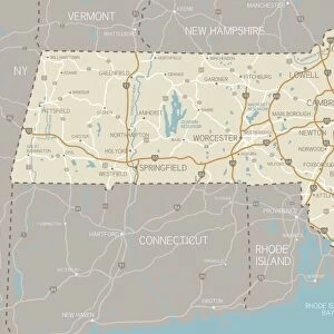
MA Franklin Leverett Vector Road Map

![]()
Wall Art and Photo Gifts from Fine Art Storehouse
MA Franklin Leverett Vector Road Map
MA Franklin Leverett Vector Road Map. All source data is in the public domain. U.S. Census Bureau Census Tiger. Used Layers: areawater, linearwater, roads, rails, cousub, pointlm, uac10
Unleash your creativity and transform your space into a visual masterpiece!
Frank Ramspott
Media ID 20690019
© Frank Ramspott, all rights reserved
City Map Computer Graphic County Digital Composite District Franklin Geographical Border Massachusetts Road Map Text Vector Digitally Generated Image Joshua Hill
FEATURES IN THESE COLLECTIONS
> Animals
> Mammals
> Cats (Wild)
> Tiger
> Animals
> Mammals
> Muridae
> Water Mouse
> Arts
> Contemporary art
> Digital artwork
> Street art
> Arts
> Landscape paintings
> Waterfall and river artworks
> River artworks
> Arts
> Portraits
> Pop art gallery
> Street art portraits
> Arts
> Street art graffiti
> Digital art
> Digital paintings
> Fine Art Storehouse
> Map
> Reference Maps
> Maps and Charts
> Related Images
> Popular Themes
> Lake District
EDITORS COMMENTS
This print showcases the intricate and detailed MA Franklin Leverett Vector Road Map. Created by talented cartographer Frank Ramspott, this digitally generated image is a testament to his exceptional design skills and expertise in creating visually stunning maps. Using various layers sourced from the public domain, including data from the U. S. Census Bureau Census Tiger, Ramspott has masterfully combined elements such as roads, rails, water bodies, cities, and towns to create a comprehensive representation of Massachusetts' physical geography. The vibrant colors and precise vector graphics bring this map to life, making it an ideal addition for any art enthusiast or geography lover. The MA Franklin Leverett Vector Road Map print does not feature any people but instead focuses solely on showcasing the geographical borders of different districts within Massachusetts. From bustling cities like Dudleyville to serene natural landmarks such as Roaring Mountain or Joshua Hill, every detail has been meticulously included in this digital composite. Whether you are looking for a unique piece of wall art or seeking inspiration for your next road trip adventure through Massachusetts' scenic routes, this visually striking map will undoubtedly captivate your imagination. With its rich colors and intricate details that highlight both urban landscapes and natural wonders alike, it serves as a perfect reminder of the beauty found within our world's diverse topography.
MADE IN THE USA
Safe Shipping with 30 Day Money Back Guarantee
FREE PERSONALISATION*
We are proud to offer a range of customisation features including Personalised Captions, Color Filters and Picture Zoom Tools
SECURE PAYMENTS
We happily accept a wide range of payment options so you can pay for the things you need in the way that is most convenient for you
* Options may vary by product and licensing agreement. Zoomed Pictures can be adjusted in the Cart.