Home > Arts > Street art graffiti > Digital art > Vector illustrations
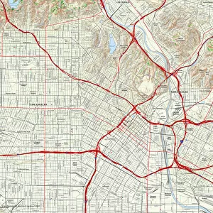
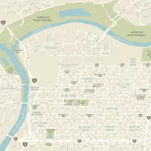
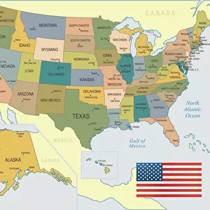
Los Angeles California US City Street Map

![]()
Wall Art and Photo Gifts from Fine Art Storehouse
Los Angeles California US City Street Map
Vector Illustration of a City Street Map of Los Angeles, California, USA. Scale 1:60, 000.
All source data is in the public domain.
U.S. Geological Survey, US Topo
Used Layers:
USGS The National Map: National Hydrography Dataset (NHD)
USGS The National Map: National Transportation Dataset (NTD)
Unleash your creativity and transform your space into a visual masterpiece!
Frank Ramspott
Media ID 15054917
© Frank Ramspott, all rights reserved
Aerial View Blue Color California Computer Graphic Directly Above Gray Color Los Angeles Road Map Street Map Text Digitally Generated Image Green Color Los Angeles River White Color
FEATURES IN THESE COLLECTIONS
> Aerial Photography
> Related Images
> Animals
> Insects
> Hemiptera
> Green Scale
> Animals
> Mammals
> Cricetidae
> California Mouse
> Arts
> Contemporary art
> Digital artwork
> Street art
> Arts
> Landscape paintings
> Waterfall and river artworks
> River artworks
> Arts
> Portraits
> Pop art gallery
> Street art portraits
> Arts
> Street art graffiti
> Digital art
> Digital paintings
> Arts
> Street art graffiti
> Digital art
> Vector illustrations
> Fine Art Storehouse
> Map
> Street Maps
> Fine Art Storehouse
> Map
> USA Maps
> Maps and Charts
> Geological Map
> Maps and Charts
> Related Images
EDITORS COMMENTS
This print showcases a meticulously detailed and visually stunning city street map of Los Angeles, California. Created with precision and artistry, this vector illustration captures the essence of the bustling metropolis. With a scale of 1:60,000, every intricate detail is brought to life in this digitally generated image. The source data used for this masterpiece is in the public domain, courtesy of U. S. Geological Survey's The National Map. It incorporates two essential datasets - the National Hydrography Dataset (NHD) and the National Transportation Dataset (NTD). These layers provide an accurate representation of various elements such as rivers, lakes, buildings, streets, roads, and more. The aerial view from directly above allows us to appreciate the vastness and complexity of Los Angeles' urban landscape. The combination of gray tones for text details along with vibrant green for parks and blue for water bodies creates a visually striking contrast against a white backdrop. This artwork by Frank Ramspott exemplifies exceptional cartography skills fused with modern design techniques. It serves as both an informative tool and an aesthetic marvel that celebrates the physical geography of one of America's most iconic cities. This print is perfect for anyone fascinated by maps or seeking to adorn their space with a unique piece that encapsulates the spirit of Los Angeles without any mention or intention towards commercial use.
MADE IN THE USA
Safe Shipping with 30 Day Money Back Guarantee
FREE PERSONALISATION*
We are proud to offer a range of customisation features including Personalised Captions, Color Filters and Picture Zoom Tools
SECURE PAYMENTS
We happily accept a wide range of payment options so you can pay for the things you need in the way that is most convenient for you
* Options may vary by product and licensing agreement. Zoomed Pictures can be adjusted in the Cart.