Home > Europe > United Kingdom > Scotland > Maps
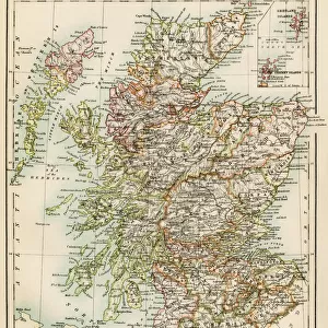
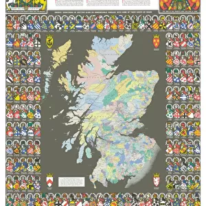
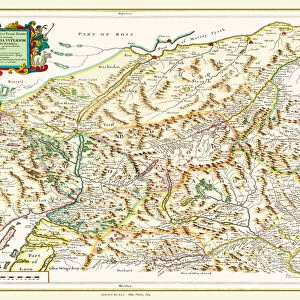
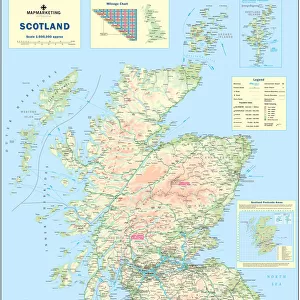
Map of Scotland, 1819, J. Mawman

![]()
Wall Art and Photo Gifts from Liszt Collection
Map of Scotland, 1819, J. Mawman
Liszt Collection of nineteenth-century engravings and images to browse and enjoy
Media ID 12804275
© Quint Lox Limited
FEATURES IN THESE COLLECTIONS
> Europe
> United Kingdom
> Scotland
> Maps
> Europe
> United Kingdom
> Scotland
> Posters
> Europe
> United Kingdom
> Scotland
> Related Images
> Maps and Charts
> Related Images
EDITORS COMMENTS
This print showcases the remarkable "Map of Scotland, 1819" created by J. Mawman. A true testament to cartographic excellence, this intricate map offers a glimpse into the past, providing a window to Scotland's rich history and breathtaking landscapes. Crafted with meticulous detail, every contour of this ancient land is meticulously illustrated on this vintage masterpiece. From the rugged peaks of the Highlands to the serene lochs that dot its surface, each element is brought to life in stunning accuracy. The delicate strokes and vibrant colors used by J. Mawman transport us back in time, allowing us to explore Scotland as it was over two centuries ago. As we delve into this historical treasure trove, we discover countless towns and villages nestled amidst rolling hills and sprawling valleys. Each one tells a story of its own; tales of battles fought and won, traditions upheld through generations, and communities thriving against all odds. Beyond geographical boundaries lie hidden gems waiting to be discovered - castles steeped in legends like Edinburgh Castle or Eilean Donan Castle; iconic landmarks such as Loch Ness or Ben Nevis that have become symbols of Scottish identity worldwide. Whether you are an avid historian or simply captivated by Scotland's enchanting allure, this print invites you on an unforgettable journey through time. Let your imagination wander across these beautifully preserved contours as you immerse yourself in the splendorous beauty that has made Scotland an eternal source of fascination for generations past and present.
MADE IN THE USA
Safe Shipping with 30 Day Money Back Guarantee
FREE PERSONALISATION*
We are proud to offer a range of customisation features including Personalised Captions, Color Filters and Picture Zoom Tools
SECURE PAYMENTS
We happily accept a wide range of payment options so you can pay for the things you need in the way that is most convenient for you
* Options may vary by product and licensing agreement. Zoomed Pictures can be adjusted in the Cart.