Home > Europe > United Kingdom > England > Birmingham > Area > Hawkesley
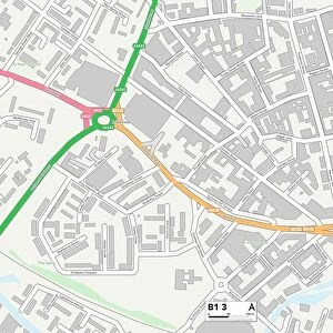
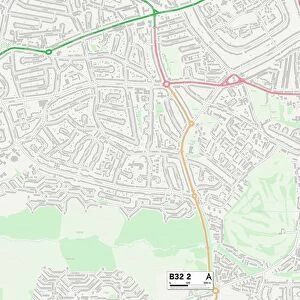
Birmingham B31 2 Map

![]()
Wall Art and Photo Gifts from Map Marketing
Birmingham B31 2 Map
Postcode Sector Map of Birmingham B31 2
Media ID 19964946
Appletree Close Belmont Crescent Birmingham Chatham Road Church Hill Church Road College Street Conifer Drive Copse Close Cornfield Road Cypress Grove Devon Way Griffin Close Hazel Croft High Street Hole Lane Knighton Road Manor House Drive Meeting House Lane Mill Lane Norman Road Northfield Oak Grove Pine Walk Quarry Lane Ramsden Close Rectory Road Rochester Road Saxon Court School Close South Road Spinney Close Sylvan Avenue The Leys Victoria Drive White Hill William Road Winchester Gardens Windmill Close Windmill Hill Woodland Road Longbridge
FEATURES IN THESE COLLECTIONS
> Animals
> Mammals
> Muridae
> Heath Mouse
> Animals
> Mammals
> Muridae
> Peters Mouse
> Arts
> Artists
> H
> William Heath
> Arts
> Artists
> H
> William Hole
> Arts
> Artists
> W
> William White
> Europe
> United Kingdom
> England
> Birmingham
> Area
> Beech Lanes
> Europe
> United Kingdom
> England
> Birmingham
> Area
> Bromford
> Europe
> United Kingdom
> England
> Birmingham
> Area
> Hawkesley
> Europe
> United Kingdom
> England
> Birmingham
> Area
> High Heath
> Map Marketing
> Postcode Sector Maps
> B - Birmingham
MADE IN THE USA
Safe Shipping with 30 Day Money Back Guarantee
FREE PERSONALISATION*
We are proud to offer a range of customisation features including Personalised Captions, Color Filters and Picture Zoom Tools
SECURE PAYMENTS
We happily accept a wide range of payment options so you can pay for the things you need in the way that is most convenient for you
* Options may vary by product and licensing agreement. Zoomed Pictures can be adjusted in the Cart.