Home > Europe > United Kingdom > Scotland > Angus > Forfar
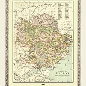
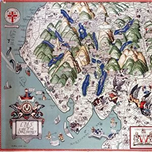
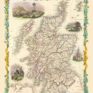
Old County Map of Forfar Scotland 1847 by A&C Black

![]()
Wall Art and Photo Gifts from MapSeeker
Old County Map of Forfar Scotland 1847 by A&C Black
A finely detailed facimile remastered in full colour from an antique original map of Forfar featured in A&C Blacks Atlas of 1847. Each Parish is numbered using an index table, colour rendition beautifully differentiating all of the Parishes. As well as principal roads, towns, villages and hamlets, these county maps of Scotland feature key battle sites marked with two crossed swords and the date of the battle
Welcome to the Mapseeker Image library and enter an historic gateway to one of the largest on-line collections of Historic Maps, Nostalgic Views, Vista's and Panorama's from a World gone by.
Media ID 20347459
© Mapseeker Publishing Ltd
A And C Black A And C Black Atlas A And C Black Map County Map County Map Of Scotland Historic Map Old County Map Old Scottish County Map Scottish County Map Angus Forfar Forfarshire
FEATURES IN THESE COLLECTIONS
> Arts
> Photorealistic artworks
> Detailed art pieces
> Masterful detailing in art
> Europe
> United Kingdom
> Scotland
> Angus
> Forfar
> Europe
> United Kingdom
> Scotland
> Angus
> Related Images
> Europe
> United Kingdom
> Scotland
> Forfarshire
> Europe
> United Kingdom
> Scotland
> Maps
> Maps and Charts
> Early Maps
> Maps and Charts
> Related Images
> MapSeeker
> Maps from the British Isles
> Scotland and Counties PORTFOLIO
EDITORS COMMENTS
This stunning print showcases the "Old County Map of Forfar, Scotland 1847" by A&C Black. Remastered in full color from an antique original map featured in A&C Blacks Atlas of 1847, this finely detailed facsimile captures the essence of historical cartography. The map is a treasure trove for history enthusiasts and researchers alike. Each Parish is meticulously numbered using an index table, allowing for easy navigation and exploration. The color rendition beautifully differentiates all of the Parishes, providing a visually captivating experience. Beyond depicting principal roads, towns, villages, and hamlets, this county map goes above and beyond by highlighting key battle sites with two crossed swords and their respective dates. This unique feature adds another layer of historical significance to the already rich tapestry presented. Forfarshire (now known as Angus) comes alive through this historic map's intricate details. It offers a glimpse into the past, allowing us to trace the evolution of this Scottish county over time. Whether you are a collector or simply appreciate Scotland's rich heritage, this old county map serves as both a decorative piece and an educational tool. Its authenticity transports viewers back to 1847 when A&C Black first published their renowned atlas. With its timeless appeal and meticulous craftsmanship, this print invites you to immerse yourself in the fascinating world of Forfarshire's history through cartographic artistry at its finest.
MADE IN THE USA
Safe Shipping with 30 Day Money Back Guarantee
FREE PERSONALISATION*
We are proud to offer a range of customisation features including Personalised Captions, Color Filters and Picture Zoom Tools
SECURE PAYMENTS
We happily accept a wide range of payment options so you can pay for the things you need in the way that is most convenient for you
* Options may vary by product and licensing agreement. Zoomed Pictures can be adjusted in the Cart.