Home > Animals > Mammals > Cats (Wild) > Populator
North America at night, satellite image

![]()
Wall Art and Photo Gifts from Science Photo Library
North America at night, satellite image
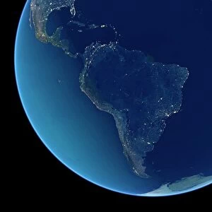
Africa at night. Satellite image of the Earth at night, set against a background of stars, centred on the continent of Africa. North is at top. City lights (yellow) show areas of dense population. Most of Africa is dark in comparison with the bright lights of the cities of Europe and the Middle East (across top). Rural and undeveloped areas in Africa include the vast Sahara desert in the north, tropical forests in central Africa, and the savannah and deserts of eastern and southern Africa. City lights seen outside Africa and Europe include part of South America (lower left), India (upper right) and islands in the Atlantic and Indian oceans. Image data obtained in 2001 by the Defense Meteorological Satellite Program (DMSP)
Science Photo Library features Science and Medical images including photos and illustrations
Media ID 1705161
© NASA/NOAA/SCIENCE PHOTO LIBRARY
2001 Artificial Back Ground Cities City Continent Continental Continents Demographics Demography Density Distribution Dmsp Earth Observation Earth Science Energy Environmental Impact From Space Globe Hemisphere Human Geography Human Population Image Inhabited Light Light Pollution Lights Night Night Time Photos Planetary Populated Population Power Satellite Satellite Image Sciences Stars Uninhabited Urban Urban Geography World
FEATURES IN THESE COLLECTIONS
> Africa
> Related Images
> Africa
> South Africa
> Related Images
> Animals
> Mammals
> Cats (Wild)
> Populator
> Animals
> Mammals
> Muridae
> Desert Mouse
> Arts
> Artists
> O
> Oceanic Oceanic
> Arts
> Landscape paintings
> Forest and woodland scenes
> Forest artwork
> Asia
> East Timor
> Related Images
> Asia
> India
> Related Images
> North America
> Related Images
> Popular Themes
> North Island
> Science Photo Library
> Aerial and Satellite
EDITORS COMMENTS
This print showcases the beauty of our planet at night, with a focus on the continent of Africa. The satellite image, taken in 2001 by the Defense Meteorological Satellite Program (DMSP), reveals North America illuminated against a backdrop of stars. However, it is Africa that truly stands out as most of its vast expanse remains shrouded in darkness compared to the bright city lights seen across Europe and the Middle East. The yellow city lights represent areas of dense population, highlighting human habitation and urban development. Beyond Africa and Europe, glimpses of other continents can be observed: South America in the lower left corner, India in the upper right corner, and islands scattered throughout the Atlantic and Indian oceans. This image not only captures Earth's artificial illumination but also offers valuable insights into global geography and demography. It portrays how human populations are distributed across continents while showcasing uninhabited regions such as deserts, tropical forests, savannahs, and undeveloped areas within Africa. Moreover, this photograph raises awareness about light pollution's environmental impact on our planet. As we marvel at these stunning city lights from space, we must also consider their energy consumption and consequences for both wildlife habitats and human well-being. In essence, this remarkable snapshot serves as a reminder of humanity's technological advancements while urging us to contemplate our responsibility towards preserving Earth's delicate balance between progress and nature's wonders.
MADE IN THE USA
Safe Shipping with 30 Day Money Back Guarantee
FREE PERSONALISATION*
We are proud to offer a range of customisation features including Personalised Captions, Color Filters and Picture Zoom Tools
SECURE PAYMENTS
We happily accept a wide range of payment options so you can pay for the things you need in the way that is most convenient for you
* Options may vary by product and licensing agreement. Zoomed Pictures can be adjusted in the Cart.