Mars topographical map, satellite image

![]()
Wall Art and Photo Gifts from Science Photo Library
Mars topographical map, satellite image
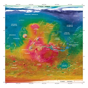
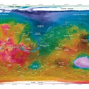
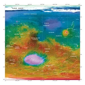
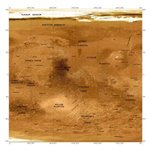
Mars topographical map. Three-dimensional composite satellite image of the surface of Mars. Topographical features are labelled in black. North is at top. Features visible include the Chryse Planitia (centre right), a plain with a diameter of around 840 kilometres, and Olympus Mons (centre left), the tallest known volcano and mountain in our solar system. The map was created using data from the Mars Global Surveyor spacecrafts Mars Orbiter Laser Altimeter
Science Photo Library features Science and Medical images including photos and illustrations
Media ID 6426703
© DETLEV VAN RAVENSWAAY/SCIENCE PHOTO LIBRARY
3 Dimensional Astrophysical Astrophysics Brown Composite Crater Craters Feature Features From Space Labelled Mapped Mars Mars Global Surveyor Mars Orbiter Laser Altimeter Martian Mola Olympus Mons Plain Plains Planetary Planetary Science Region Regions Satellite Image Solar System Space Craft Surface Tallest Three Dimensional Topographic Topographical Topography Volcano Volcanoes
MADE IN THE USA
Safe Shipping with 30 Day Money Back Guarantee
FREE PERSONALISATION*
We are proud to offer a range of customisation features including Personalised Captions, Color Filters and Picture Zoom Tools
SECURE PAYMENTS
We happily accept a wide range of payment options so you can pay for the things you need in the way that is most convenient for you
* Options may vary by product and licensing agreement. Zoomed Pictures can be adjusted in the Cart.