Home > Universal Images Group (UIG) > Art > Painting, Sculpture & Prints > Cartography
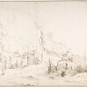
Map of Tours and Angers from Civitates Orbis Terrarum by Georg Braun, 1541-1622 and Franz Hogenberg, 1540-1590, engraving

![]()
Wall Art and Photo Gifts from Universal Images Group (UIG)
Map of Tours and Angers from Civitates Orbis Terrarum by Georg Braun, 1541-1622 and Franz Hogenberg, 1540-1590, engraving
Cartography, France, 16th century. Map of Tours and Angers. From Civitates Orbis Terrarum by Georg Braun (1541-1622) and Franz Hogenberg (1540-1590), Cologne. Engraving
Universal Images Group (UIG) manages distribution for many leading specialist agencies worldwide
Media ID 9570361
© DEA / R. MERLO
16th Century Elevated View Horizon Over Land Manuscript Tours Townscape Angers
EDITORS COMMENTS
This print showcases a remarkable piece of cartographic history, the "Map of Tours and Angers" from Civitates Orbis Terrarum by Georg Braun and Franz Hogenberg. Created in the 16th century, this engraving is a testament to the meticulous craftsmanship and artistry of its time. The map offers an elevated view of these French towns, presenting a detailed townscape that transports us back in time. The intricate architecture and landscape depicted on the map provide valuable insights into the physical geography and historical significance of Tours and Angers. With no people present in this studio shot, our focus is solely on the horizon over land. This allows us to appreciate both the artistic representation as well as the accuracy with which these cities were mapped centuries ago. As we delve into this mesmerizing artwork, we are reminded of how maps have long served as essential tools for exploration, navigation, and understanding our world. This particular engraving not only serves those purposes but also stands as a work of art in itself. Whether you are an enthusiast for history or simply appreciate fine illustrations, this print captures both beauty and knowledge within its frame. It invites viewers to immerse themselves in France's rich cultural heritage while marveling at the skillful blend of cartography and human representation brought forth by Braun and Hogenberg.
MADE IN THE USA
Safe Shipping with 30 Day Money Back Guarantee
FREE PERSONALISATION*
We are proud to offer a range of customisation features including Personalised Captions, Color Filters and Picture Zoom Tools
SECURE PAYMENTS
We happily accept a wide range of payment options so you can pay for the things you need in the way that is most convenient for you
* Options may vary by product and licensing agreement. Zoomed Pictures can be adjusted in the Cart.