Home > Arts > Contemporary art > Digital artwork > Street art
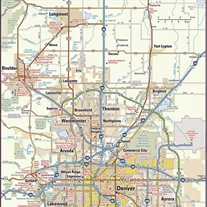
MA Franklin Buckland Vector Road Map

![]()
Wall Art and Photo Gifts from Fine Art Storehouse
MA Franklin Buckland Vector Road Map
MA Franklin Buckland Vector Road Map. All source data is in the public domain. U.S. Census Bureau Census Tiger. Used Layers: areawater, linearwater, roads, rails, cousub, pointlm, uac10
Unleash your creativity and transform your space into a visual masterpiece!
Frank Ramspott
Media ID 20690237
© Frank Ramspott, all rights reserved
City Map Computer Graphic County Digital Composite District Franklin Geographical Border Massachusetts Road Map Text Vector Bald Mountain Buckland Digitally Generated Image Shelburne Falls Snow Mountain
FEATURES IN THESE COLLECTIONS
> Animals
> Mammals
> Cats (Wild)
> Tiger
> Animals
> Mammals
> Muridae
> Water Mouse
> Arts
> Contemporary art
> Digital artwork
> Street art
> Arts
> Landscape paintings
> Waterfall and river artworks
> River artworks
> Arts
> Portraits
> Pop art gallery
> Street art portraits
> Arts
> Street art graffiti
> Digital art
> Digital paintings
> Fine Art Storehouse
> Map
> Reference Maps
> Maps and Charts
> Related Images
> Popular Themes
> Lake District
EDITORS COMMENTS
This print showcases the MA Franklin Buckland Vector Road Map, a stunning piece of cartography art created by Frank Ramspott. The artist skillfully combines various layers sourced from the public domain, including data from the U. S. Census Bureau Census Tiger, to craft this visually striking and informative map. The design features an array of vibrant colors and intricate details that bring life to Massachusetts' geographical borders. From bustling cities to charming towns, every element is meticulously depicted in this digitally generated image. Rivers gracefully wind their way across the landscape while lakes shimmer under the sunlight, adding a touch of serenity to the composition. Notably absent are any human figures; instead, this artwork focuses solely on showcasing nature's beauty and highlighting the state's diverse physical geography. Roads and railways crisscross through different regions, connecting communities with ease. Text labels guide viewers through notable landmarks such as Franklin, Buckland, Shelburne Falls, The Patten, Hog Mountain, Snow Mountain, Shirkshire, Shattuckville Massaemett Mountain and Bald Mountain - each contributing its own unique charm to Massachusetts' landscape. This print is perfect for those who appreciate both artistry and functionality. Whether displayed in a home or office space or used as a reference tool for navigation purposes – it effortlessly blends aesthetics with practicality.
MADE IN THE USA
Safe Shipping with 30 Day Money Back Guarantee
FREE PERSONALISATION*
We are proud to offer a range of customisation features including Personalised Captions, Color Filters and Picture Zoom Tools
SECURE PAYMENTS
We happily accept a wide range of payment options so you can pay for the things you need in the way that is most convenient for you
* Options may vary by product and licensing agreement. Zoomed Pictures can be adjusted in the Cart.