Home > Aerial Photography > Related Images
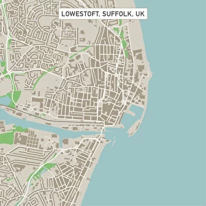
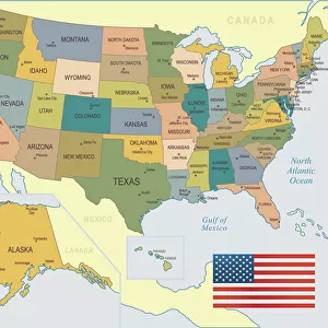
Corpus Christi Texas US City Street Map

![]()
Wall Art and Photo Gifts from Fine Art Storehouse
Corpus Christi Texas US City Street Map
Vector Illustration of a City Street Map of Corpus Christi, Texas, USA. Scale 1:60, 000.
All source data is in the public domain.
U.S. Geological Survey, US Topo
Used Layers:
USGS The National Map: National Hydrography Dataset (NHD)
USGS The National Map: National Transportation Dataset (NTD)
Unleash your creativity and transform your space into a visual masterpiece!
Frank Ramspott
Media ID 15192978
© Frank Ramspott, all rights reserved
Aerial View City Map Computer Graphic Directly Above Downtown District Gray Road Map Texas Text Corpus Christi Digitally Generated Image Green Color White Color
FEATURES IN THESE COLLECTIONS
> Aerial Photography
> Related Images
> Animals
> Insects
> Hemiptera
> Green Scale
> Arts
> Contemporary art
> Digital artwork
> Street art
> Arts
> Landscape paintings
> Waterfall and river artworks
> River artworks
> Arts
> Portraits
> Pop art gallery
> Street art portraits
> Arts
> Street art graffiti
> Digital art
> Digital paintings
> Arts
> Street art graffiti
> Digital art
> Vector illustrations
> Fine Art Storehouse
> Map
> Street Maps
> Fine Art Storehouse
> Map
> USA Maps
> Maps and Charts
> Geological Map
> Maps and Charts
> Related Images
> North America
> United States of America
> Lakes
> Related Images
EDITORS COMMENTS
This print showcases a detailed and visually stunning city street map of Corpus Christi, Texas, USA. Created as a vector illustration with a scale of 1:60,000, this artwork beautifully captures the essence of the city's downtown district, complete with its intricate network of streets and roads. The artist has utilized various layers from reliable sources such as the U. S. Geological Survey (USGS) to ensure accuracy and authenticity in depicting essential features like the National Hydrography Dataset (NHD) and National Transportation Dataset (NTD). The result is an intricately designed cartographic masterpiece that offers both practicality and aesthetic appeal. Rendered in vibrant colors including shades of gray, blue, white, and green, this digitally generated image provides an aerial view directly above Corpus Christi. With no people present in the scene, viewers can focus solely on exploring every corner of this fascinating city map. Frank Ramspott's skillful execution brings out the physical geography of Corpus Christi with remarkable precision. Whether you are a resident or simply fascinated by urban landscapes, this print is sure to captivate your imagination while serving as an excellent reference tool for navigating through one of Texas' most vibrant cities.
MADE IN THE USA
Safe Shipping with 30 Day Money Back Guarantee
FREE PERSONALISATION*
We are proud to offer a range of customisation features including Personalised Captions, Color Filters and Picture Zoom Tools
SECURE PAYMENTS
We happily accept a wide range of payment options so you can pay for the things you need in the way that is most convenient for you
* Options may vary by product and licensing agreement. Zoomed Pictures can be adjusted in the Cart.