Home > Arts > Artists > H > Jodocus Hondius
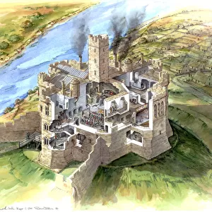
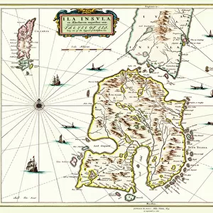
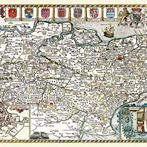
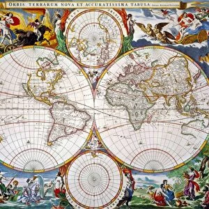
Old County Map of Middlesex 1648 by Johan Blaue from the Atlas Novus

![]()
Wall Art and Photo Gifts from MapSeeker
Old County Map of Middlesex 1648 by Johan Blaue from the Atlas Novus
This detailed and most attractive reproduction map of Middlesex has been carefully art worked from a scan of an antique original. The famous firm of Dutch cartographers and publishers was established in the late 16th century by Willem Janszoon Blaeu in Amsterdam. Blaeu was a maker of globes and scientific instruments and purchased some of his early map plates from Jodocus Hondius. From this small beginning was to emerge one of the largest and most prolific map publishing houses of the seventeenth century
Welcome to the Mapseeker Image library and enter an historic gateway to one of the largest on-line collections of Historic Maps, Nostalgic Views, Vista's and Panorama's from a World gone by.
Media ID 20347683
Blaeu Blaeu Family Blaue Map County Map County Map Of England English County Map Historic Map Johan Blaeu Johan Blaeu Map Old Blaue Map Old County Map Old English County Map Middlesex
FEATURES IN THESE COLLECTIONS
> Arts
> Artists
> B
> Willem Blaeu
> Arts
> Artists
> H
> Jodocus Hondius
> Arts
> Photorealistic artworks
> Detailed art pieces
> Masterful detailing in art
> Europe
> United Kingdom
> England
> Maps
> Europe
> United Kingdom
> England
> Middlesex
> Related Images
> Maps and Charts
> Early Maps
> Maps and Charts
> Related Images
> Maps and Charts
> Willem Janszoon Blaeu
> MapSeeker
> Maps from the British Isles
> England and Counties PORTFOLIO
EDITORS COMMENTS
This beautifully crafted reproduction of the "Old County Map of Middlesex 1648" by Johan Blaue from the Atlas Novus takes us back in time to explore the historical landscape of England. Carefully art worked from an antique original, this detailed and captivating map offers a glimpse into the rich cartographic heritage of the renowned Dutch firm. Established in Amsterdam during the late 16th century by Willem Janszoon Blaeu, a skilled maker of globes and scientific instruments, this family-run business quickly rose to prominence. Acquiring some map plates from Jodocus Hondius at its inception, it grew into one of the largest and most prolific map publishing houses of the seventeenth century. The Middlesex county map presented here showcases not only Blaeu's exceptional craftsmanship but also his dedication to accuracy and precision. Every contour, river, town, and road is meticulously depicted on this historic piece. It serves as a testament to both artistic skill and geographical knowledge prevalent during that era. Transporting us back in time with its intricate details and elegant aesthetics, this old English county map allows us to trace our roots through history. Whether you are an avid collector or simply fascinated by cartography's evolution over time, this remarkable reproduction is sure to captivate your imagination as you explore Middlesex's past.
MADE IN THE USA
Safe Shipping with 30 Day Money Back Guarantee
FREE PERSONALISATION*
We are proud to offer a range of customisation features including Personalised Captions, Color Filters and Picture Zoom Tools
SECURE PAYMENTS
We happily accept a wide range of payment options so you can pay for the things you need in the way that is most convenient for you
* Options may vary by product and licensing agreement. Zoomed Pictures can be adjusted in the Cart.