Home > Europe > United Kingdom > England > London > Towns > Welling
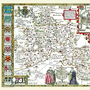
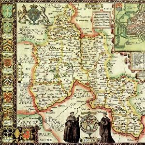
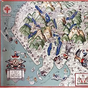
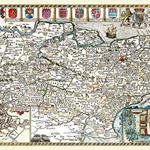
Old County Map of Oxfordshire 1836 by Thomas Moule

![]()
Wall Art and Photo Gifts from MapSeeker
Old County Map of Oxfordshire 1836 by Thomas Moule
This is a fine decorative reproduction County Map of Oxfordshire from the First Edition series of Thomas Moule Maps, originally Published in 1836. The well-known series of County Maps which are known as Moules feature beautiful vignette views and were first published in separate sections for each county in 1830-32, they were then published in collected form in a two-volume work: The English Counties Delineated: or a Topographical Description of England: Illustrated by a Complete Series of County Maps by Thomas Moule: London: Published by George Virtue 1836
Welcome to the Mapseeker Image library and enter an historic gateway to one of the largest on-line collections of Historic Maps, Nostalgic Views, Vista's and Panorama's from a World gone by.
Media ID 20347915
© Mapseeker Publishing Ltd
County Map County Map Of England English County Map Historic Map Moule Map Old County Map Old English County Map Old Moule Map Thomas Moule Thomas Moule Map Oxfordshire
FEATURES IN THESE COLLECTIONS
> Arts
> Artists
> M
> Thomas Moule
> Europe
> United Kingdom
> England
> London
> Towns
> Welling
> Europe
> United Kingdom
> England
> Maps
> Europe
> United Kingdom
> England
> Oxfordshire
> Related Images
> Europe
> United Kingdom
> England
> Wells
> Maps and Charts
> Early Maps
> Maps and Charts
> Related Images
> MapSeeker
> Maps from the British Isles
> England and Counties PORTFOLIO
EDITORS COMMENTS
This exquisite print showcases the "Old County Map of Oxfordshire 1836" by Thomas Moule, a renowned cartographer of his time. Originally published in 1836 as part of Moule's First Edition series, this decorative reproduction offers a glimpse into the rich history and topography of Oxfordshire. Moule's county maps are celebrated for their intricate details and captivating vignette views. Each map was meticulously crafted to provide an accurate representation of the region it depicted. The collection was first released between 1830 and 1832, with individual sections dedicated to each county. In 1836, these remarkable maps were compiled into a two-volume work titled "The English Counties Delineated: or a Topographical Description of England" published by George Virtue in London. This particular print transports us back in time, allowing us to explore the historical landscape of Oxfordshire through Moule's expertly drawn lines and symbols. It serves as both an educational resource for those interested in local history and a stunning piece of art that can enhance any space with its vintage charm. Whether you're an avid collector of historic maps or simply appreciate the beauty they hold, this old county map is sure to captivate your imagination and transport you to another era. Discover the enchanting allure of Oxfordshire as seen through Thomas Moule's eyes with this remarkable photo print.
MADE IN THE USA
Safe Shipping with 30 Day Money Back Guarantee
FREE PERSONALISATION*
We are proud to offer a range of customisation features including Personalised Captions, Color Filters and Picture Zoom Tools
SECURE PAYMENTS
We happily accept a wide range of payment options so you can pay for the things you need in the way that is most convenient for you
* Options may vary by product and licensing agreement. Zoomed Pictures can be adjusted in the Cart.