Home > Maps and Charts > Related Images
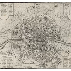
Two Maps of Central Europe that illustrate how the region looked during the years of conflict between AD 1795 and AD 1803

![]()
Wall Art and Photo Gifts from MapSeeker
Two Maps of Central Europe that illustrate how the region looked during the years of conflict between AD 1795 and AD 1803
EHIST011
Welcome to the Mapseeker Image library and enter an historic gateway to one of the largest on-line collections of Historic Maps, Nostalgic Views, Vista's and Panorama's from a World gone by.
Media ID 20348270
Europe Europe Map Map Of Europe
FEATURES IN THESE COLLECTIONS
> Maps and Charts
> Related Images
> MapSeeker
> Maps of Europe
> Old Maps of Europe and Small Islands of
EDITORS COMMENTS
This print showcases two historical maps of Central Europe, shedding light on the tumultuous period between AD 1795 and AD 1803. These meticulously detailed maps provide a visual narrative of the region during a time marked by intense conflict and political upheaval. The first map depicts Central Europe in AD 1795, capturing the aftermath of the partitions that had divided Poland-Lithuania among its neighboring powers: Russia, Prussia, and Austria. The borders are clearly delineated, showcasing how these dominant nations carved up this once-thriving kingdom. This partitioning was not only a territorial reconfiguration but also an event that sparked tensions and rivalries throughout the continent. The second map represents Central Europe in AD 1803, illustrating significant changes resulting from subsequent conflicts and power struggles within the region. Borders have shifted as empires expanded or contracted through conquests or treaties. This dynamic landscape reflects both military campaigns waged across European soil and diplomatic negotiations aimed at maintaining balance amidst growing ambitions. These two maps together offer invaluable insights into an era characterized by geopolitical transformations and territorial disputes that shaped modern-day Europe. They serve as powerful historical artifacts reminding us of how boundaries were redrawn with profound consequences for nations and individuals alike. MapSeeker's preservation of these remarkable prints allows us to delve into history's pages visually, unraveling narratives embedded within each line drawn on these ancient maps—truly illuminating our understanding of this pivotal period in European history.
MADE IN THE USA
Safe Shipping with 30 Day Money Back Guarantee
FREE PERSONALISATION*
We are proud to offer a range of customisation features including Personalised Captions, Color Filters and Picture Zoom Tools
SECURE PAYMENTS
We happily accept a wide range of payment options so you can pay for the things you need in the way that is most convenient for you
* Options may vary by product and licensing agreement. Zoomed Pictures can be adjusted in the Cart.