Home > Europe > United Kingdom > Scotland > Edinburgh > Edinburgh
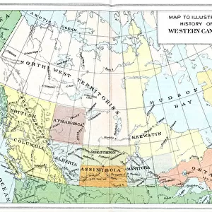
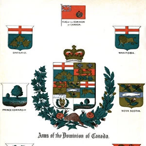
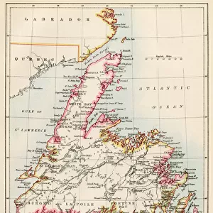
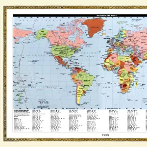
Map of the Dominion of Canada, 1902. Creator: Unknown

![]()
Wall Art and Photo Gifts from Heritage Images
Map of the Dominion of Canada, 1902. Creator: Unknown
Map of the Dominion of Canada, 1902. Showing the various provinces. From The Century Atlas of the World. [John Walker & Co, Ltd. London, 1902]
Heritage Images features heritage image collections
Media ID 15512218
© The Print Collector / Heritage-Images
Canada Edinburgh Geographical Institute Great Lakes North America Province Provinces Dominion Of Canada
FEATURES IN THESE COLLECTIONS
> Europe
> United Kingdom
> Scotland
> Edinburgh
> Edinburgh
> Europe
> United Kingdom
> Scotland
> Lothian
> Edinburgh
> Maps and Charts
> Related Images
> Maps and Charts
> World
> North America
> Canada
> Lakes
> Related Images
> North America
> Canada
> Maps
> North America
> Canada
> Related Images
EDITORS COMMENTS
This print showcases a historical treasure - the Map of the Dominion of Canada, dating back to 1902. Created by an unknown cartographer, this map offers a fascinating glimpse into the country's provinces and their geographical locations during that era. The Century Atlas of the World published it in London in collaboration with John Walker & Co. In vivid color, this beautifully detailed map highlights Canada's vast territory and its various provinces. From coast to coast, it encompasses everything from the Great Lakes region to remote northern territories. This snapshot from history allows us to trace Canada's growth and development as a nation. The Edinburgh Geographical Institute played a crucial role in bringing this masterpiece to life, ensuring accuracy and precision in depicting each province. While we may not know who specifically crafted this map, its enduring significance remains undeniable. Preserved by The Print Collector, this image captures more than just lines on paper; it represents an invaluable piece of Canadian heritage. As we explore this visual representation of our past, let us appreciate the dedication and craftsmanship involved in creating such intricate maps over a century ago.
MADE IN THE USA
Safe Shipping with 30 Day Money Back Guarantee
FREE PERSONALISATION*
We are proud to offer a range of customisation features including Personalised Captions, Color Filters and Picture Zoom Tools
SECURE PAYMENTS
We happily accept a wide range of payment options so you can pay for the things you need in the way that is most convenient for you
* Options may vary by product and licensing agreement. Zoomed Pictures can be adjusted in the Cart.