Home > Arts > Realistic drawings > Pencil drawings > Animal drawings
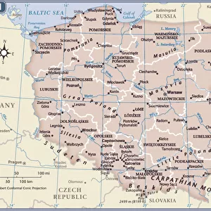
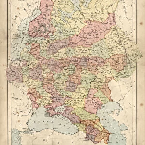
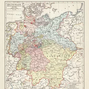
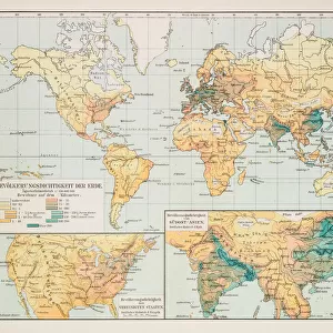
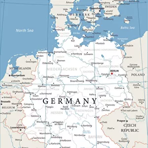
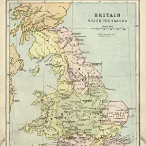
Prussia historical map

![]()
Wall Art and Photo Gifts from Fine Art Storehouse
Prussia historical map
Illustration of a Prussia historical development map
Unleash your creativity and transform your space into a visual masterpiece!
Nastasic
Media ID 13592449
© Nikola Nastasic
Aging Process Antiquities Art Product Atlas Baltic Countries Brandenburg Chart Computer Graphic Computer Graphics Denmark European Culture Geographical Locations Illustrated Kingdom Monoprint North Painting Paintings Pencil Drawing Pictorial Picture Poland Printout Prussia Revival State Territorial Territorial Animal Topography World Map Drawing Art Product Obsolete Retro Styled
FEATURES IN THESE COLLECTIONS
> Arts
> Realistic drawings
> Pencil drawings
> Animal drawings
> Arts
> Realistic drawings
> Pencil drawings
> Fine art
> Europe
> Denmark
> Paintings
> Europe
> Denmark
> Related Images
> Europe
> Germany
> Paintings
> Europe
> Germany
> Related Images
> Fine Art Storehouse
> The Magical World of Illustration
> Nastasic Images & Illustrations
> Fine Art Storehouse
> Map
> Denmark Maps
> Fine Art Storehouse
> Map
> Historical Maps
EDITORS COMMENTS
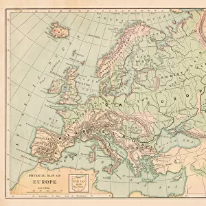
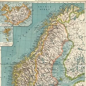
This print showcases a Prussia historical map, taking us on a journey through time and European culture. With its retro-styled design and antique charm, this illustration beautifully captures the intricate details of Prussia's territorial development. The engraved image resembles an etching or pencil drawing, adding to its nostalgic appeal. The topography of Prussia is meticulously depicted in this art product, showcasing the physical geography of the region. From the North Sea to Poland and the Baltic countries, every geographical location is intricately illustrated. The Kingdom of Prussia's borders are clearly defined, including Brandenburg in Germany and Denmark. As we gaze upon this aged printout, it evokes a sense of history and ancient cultures long past. It serves as a reminder of how boundaries have shifted over time and how different states once existed within Europe. The craftsmanship behind this artwork is evident in its detailed depiction of landforms and water bodies. The artist has skillfully combined computer graphics with traditional techniques such as engraving to create a unique visual experience. Whether you are an enthusiast for cartography or simply appreciate art that tells stories from the past, this Prussia historical map print by Nastasic will transport you back in time while adorning your space with elegance and sophistication.
MADE IN THE USA
Safe Shipping with 30 Day Money Back Guarantee
FREE PERSONALISATION*
We are proud to offer a range of customisation features including Personalised Captions, Color Filters and Picture Zoom Tools
SECURE PAYMENTS
We happily accept a wide range of payment options so you can pay for the things you need in the way that is most convenient for you
* Options may vary by product and licensing agreement. Zoomed Pictures can be adjusted in the Cart.