Home > Europe > United Kingdom > England > London > Boroughs > Islington
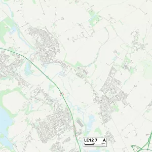
Leicester LE2 6 Map

![]()
Wall Art and Photo Gifts from Map Marketing
Leicester LE2 6 Map
Postcode Sector Map of Leicester LE2 6
Media ID 19973619
Baldwin Road Belton Close Bloomfield Road Bluebell Drive Broughton Road Burns Street Burnside Road Cheviot Road Cowper Street Damson Drive Durham Drive Fairholme Road Farm Close Ferndale Road Grampian Close Greenside Place Heather Road Helmsley Road Herrick Road Highgate Highgate Drive Hillcrest Road Holly Close Keble Road Kingsley Street Larchwood Close Leicester Longfellow Road Marriott Road Meadow Gardens Morris Road Neston Road Oakdene Road Oakland Road Percy Road Pope Street Poppy Close Robin Close Scott Court Scott Street Shelley Street Shrewsbury Avenue Sutton Road The Cedars The Crossway The Fairway Uplands Road Westbury Road Wheatsheaf Way Woodcroft Avenue Wordsworth Road Wren Close
FEATURES IN THESE COLLECTIONS
> Animals
> Birds
> Passerines
> Wrens
> House Wren
> Europe
> United Kingdom
> England
> Durham
> Durham
> Europe
> United Kingdom
> England
> Durham
> Hill End
> Europe
> United Kingdom
> England
> London
> Boroughs
> Islington
> Europe
> United Kingdom
> Northern Ireland
> County Armagh
> Newry
> Europe
> United Kingdom
> Wales
> Flintshire
> Broughton
> Europe
> United Kingdom
> Wales
> Gwynedd
> Barmouth
> Europe
> United Kingdom
> Wales
> Powys
> Knighton
> Map Marketing
> Postcode Sector Maps
> LE - Leicester
> Maps and Charts
> Related Images
MADE IN THE USA
Safe Shipping with 30 Day Money Back Guarantee
FREE PERSONALISATION*
We are proud to offer a range of customisation features including Personalised Captions, Color Filters and Picture Zoom Tools
SECURE PAYMENTS
We happily accept a wide range of payment options so you can pay for the things you need in the way that is most convenient for you
* Options may vary by product and licensing agreement. Zoomed Pictures can be adjusted in the Cart.