Home > Europe > United Kingdom > England > Bedfordshire > Great Ouse
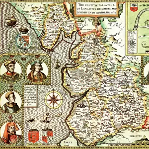
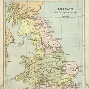
Old County Map of Bedfordshire 1611 by John Speed

![]()
Wall Art and Photo Gifts from MapSeeker
Old County Map of Bedfordshire 1611 by John Speed
A fine reproduction of John Speeds historical map of Bedfordshire originally published for the " Theatre of the Empire of Great Britain", an atlas to accompany " a history of Great Britain".
In the top right hand corner of this beautiful map is town plan of Bedford, which includes a legend listing all the street names, churches and important buildings. Just beneath this are three coats of arms of the Dukes of Bedford. The towns of Woburn, Luton and Dunstable are clearly marked, also shown are all of the ancient deer parks of this county. In the bottom left corner of the map is a short history describing how in legend the River Ouse stopped flowing
Welcome to the Mapseeker Image library and enter an historic gateway to one of the largest on-line collections of Historic Maps, Nostalgic Views, Vista's and Panorama's from a World gone by.
Media ID 20347761
© Mapseeker Publishing Ltd
County Map County Map Of England English County Map Historic Map John Speed Map Old County Map Old English County Map Speed Map Speede Map Bedfordshire
FEATURES IN THESE COLLECTIONS
> Arts
> Artists
> S
> John Speed
> Europe
> United Kingdom
> England
> Bedfordshire
> Bedford
> Europe
> United Kingdom
> England
> Bedfordshire
> Dunstable
> Europe
> United Kingdom
> England
> Bedfordshire
> Great Ouse
> Europe
> United Kingdom
> England
> Bedfordshire
> Luton
> Europe
> United Kingdom
> England
> Bedfordshire
> Related Images
> Europe
> United Kingdom
> England
> Bedfordshire
> Woburn
> Europe
> United Kingdom
> England
> Maps
> Europe
> United Kingdom
> England
> Rivers
> Maps and Charts
> British Empire Maps
EDITORS COMMENTS
This stunning print showcases John Speed's Old County Map of Bedfordshire from 1611. Originally published for the "Theatre of the Empire of Great Britain" an atlas accompanying a history of Great Britain, this fine reproduction captures the intricate details and historical significance of the original map. In the top right corner, we find a town plan of Bedford, complete with a legend listing all street names, churches, and important buildings. Just below it proudly sit three coats of arms belonging to the Dukes of Bedford. The towns of Woburn, Luton, and Dunstable are clearly marked on the map as well. Additionally, all ancient deer parks in this county are thoughtfully included. A fascinating aspect can be found in the bottom left corner—a short history recounts a legendary tale where it is believed that River Ouse ceased to flow at some point in time. This intriguing detail adds an extra layer to our understanding and appreciation for this historical piece. With its old English charm and meticulous attention to detail, this print serves as both a decorative item and an educational tool. Whether you have personal ties to Bedfordshire or simply appreciate historic maps, John Speed's work offers a captivating glimpse into England's past.
MADE IN THE USA
Safe Shipping with 30 Day Money Back Guarantee
FREE PERSONALISATION*
We are proud to offer a range of customisation features including Personalised Captions, Color Filters and Picture Zoom Tools
SECURE PAYMENTS
We happily accept a wide range of payment options so you can pay for the things you need in the way that is most convenient for you
* Options may vary by product and licensing agreement. Zoomed Pictures can be adjusted in the Basket.