Home > Europe > France > Canton > Landes
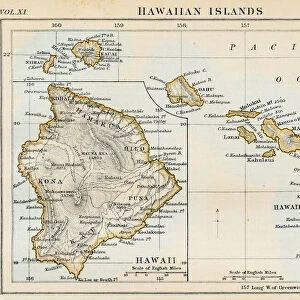
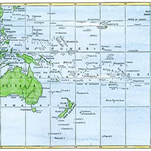
Map of Hawaii, Pacific Ocean and surrounding areas

![]()
Wall Art and Photo Gifts from Mary Evans Picture Library
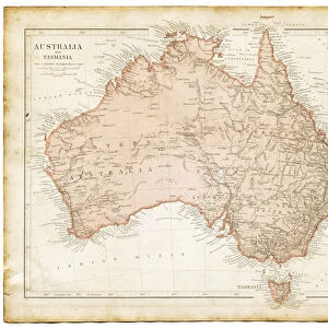
Map of Hawaii, Pacific Ocean and surrounding areas
Map of Hawaiian Islands, Pacific Ocean and the surrounding areas.
1911
Mary Evans Picture Library makes available wonderful images created for people to enjoy over the centuries
Media ID 14232184
© Mary Evans / Pharcide
Alaska Canoe Hawaii Hawaiian Maps Pacific Palm Philippines Rowing Samoa Siberia Zealand
FEATURES IN THESE COLLECTIONS
> Arts
> Artists
> O
> Oceanic Oceanic
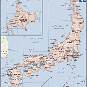
> Asia
> Japan
> Related Images
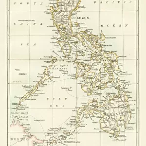
> Asia
> Philippines
> Maps
> Asia
> Philippines
> Related Images
> Europe
> France
> Canton
> Landes
EDITORS COMMENTS
1911: A Vintage Map of Hawaii and the Surrounding Pacific Ocean Regions This vintage map, dated 1911, offers a glimpse into the geography of the Pacific Ocean and the surrounding lands, with a particular focus on the Hawaiian Islands. The map, produced during the early 1910s, was created at a time when international travel and exploration were becoming increasingly popular. The map, which is part of the extensive collection at Mary Evans Prints Online, showcases the Hawaiian Islands in exquisite detail, with their names clearly labeled. The islands are depicted as lush and verdant, with palm trees adorning their shores. The map also highlights the Pacific Ocean, stretching out in all directions, with various other islands and landmasses, including Alaska, Canada, Samoa, New Zealand, Australia, the Philippines, Japan, China, and Siberia, scattered around its edges. The map also features several illustrations, including a canoe and a boat with rowers, which add to its charming and nostalgic appeal. The map's intricate detailing and beautiful design make it a fascinating historical artifact, providing a glimpse into the geography and exploration of the Pacific Ocean and its surrounding regions during the early 20th century. Whether you're an avid collector of vintage maps, a history buff, or simply someone who appreciates the beauty of old maps, this stunning 1911 map of Hawaii and the Pacific Ocean is a must-have addition to your collection. It's a reminder of a bygone era, a time when exploration and discovery were at the forefront of human endeavor. So take a moment to step back in time and lose yourself in the intricate detail and captivating design of this beautiful vintage map.
MADE IN THE USA
Safe Shipping with 30 Day Money Back Guarantee
FREE PERSONALISATION*
We are proud to offer a range of customisation features including Personalised Captions, Color Filters and Picture Zoom Tools
SECURE PAYMENTS
We happily accept a wide range of payment options so you can pay for the things you need in the way that is most convenient for you
* Options may vary by product and licensing agreement. Zoomed Pictures can be adjusted in the Cart.